Projects
Norway 2024
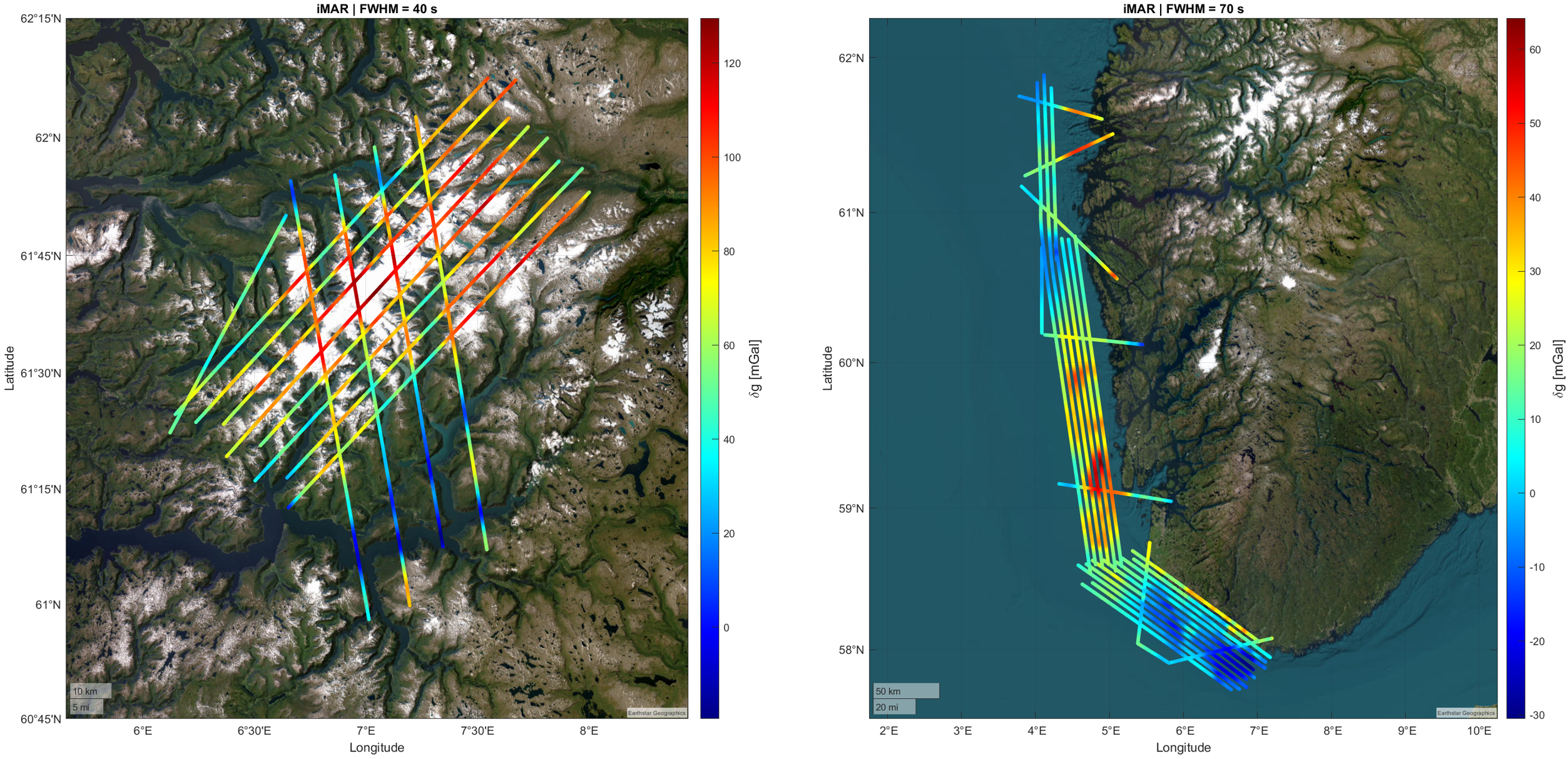
DTU Space on behalf of the Norwegian Mapping Authority conducted an airborne gravimetry campaign over Norway in December 2024. The survey aimed to acquire high-resolution gravity data in regions where conventional terrestrial and marine observations are sparse or difficult to obtain. The first survey area comprised the southwestern Norwegian coastline, targeting the marginal land-sea zone. The second survey area focused on Jostedalsbreen, the largest glacier in mainland Europe. This region is characterised by strong gravity gradients caused by complex topography, including high terrain, deep fjords, and extensive glacier systems.
The data acquisition was based on strapdown airborne gravimetry, using a navigation-grade inertial measurement unit (IMU) integrated with Global Navigation Satellite System (GNSS) observations. The data accuracy is determined by crossover analysis yielding unadjusted root-mean-square errors of 1.63 mGal in the coastal region and 1.35 mGal over Jostedalsbreen. The optimal filtering parameters differed between the two regions reflecting differences in signal characteristics and terrain roughness.
External validation was performed through comparison with existing DTU global gravity models derived from satellite altimetry. Standard deviations of the differences ranged from approximately 3.66 to 3.28 mGal indicating the limitations of existing satellite-derived gravity fields in coastal zones. Improved agreement was observed when comparing with a preliminary DTU26 model incorporating data from the Surface Water and Ocean Topography (SWOT) mission resulting in standard deviation of approximately 2.85 mGal.
The airborne gravity data identified outliers and inconsistencies in existing marine gravity datasets. Long-wavelength residual patterns between satellite altimetry and marine gravity data were found to coincide with previously identified questionable geostrophic current signals in geodetic mean dynamic topography models. This suggests the presence of systematic errors in the underlying gravimetric geoid models. These results will contribute to the improvement of regional and global gravity field models and provide essential data for the development of the next generation Nordic geoid and height reference systems.
A preprint with analysis of the results named "Airborne gravimetry mapping of coastal and glacial regions in Norway with implications for the next Nordic geoid model" available at https://doi.org/10.21203/rs.3.rs-9190249/v1
The data acquisition was based on strapdown airborne gravimetry, using a navigation-grade inertial measurement unit (IMU) integrated with Global Navigation Satellite System (GNSS) observations. The data accuracy is determined by crossover analysis yielding unadjusted root-mean-square errors of 1.63 mGal in the coastal region and 1.35 mGal over Jostedalsbreen. The optimal filtering parameters differed between the two regions reflecting differences in signal characteristics and terrain roughness.
External validation was performed through comparison with existing DTU global gravity models derived from satellite altimetry. Standard deviations of the differences ranged from approximately 3.66 to 3.28 mGal indicating the limitations of existing satellite-derived gravity fields in coastal zones. Improved agreement was observed when comparing with a preliminary DTU26 model incorporating data from the Surface Water and Ocean Topography (SWOT) mission resulting in standard deviation of approximately 2.85 mGal.
The airborne gravity data identified outliers and inconsistencies in existing marine gravity datasets. Long-wavelength residual patterns between satellite altimetry and marine gravity data were found to coincide with previously identified questionable geostrophic current signals in geodetic mean dynamic topography models. This suggests the presence of systematic errors in the underlying gravimetric geoid models. These results will contribute to the improvement of regional and global gravity field models and provide essential data for the development of the next generation Nordic geoid and height reference systems.
A preprint with analysis of the results named "Airborne gravimetry mapping of coastal and glacial regions in Norway with implications for the next Nordic geoid model" available at https://doi.org/10.21203/rs.3.rs-9190249/v1